|
The
bordermarkers of Luxembourg
Luxembourg has 3 neighbouring countries: Belgium, Germany and France. Each border has its own set or multiple sets of bordermarkers. This webpage summarizes the facts abouts these bordermarkers: treaties, other sources, links to websites and so on. (website by Eef Berns, created in 2024, part of www.grenspalen.nl, contact: eefberns@grenspalen.nl) |
|---|
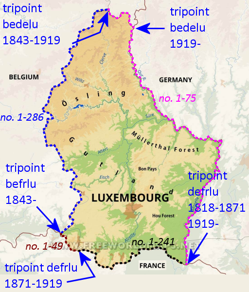 Short bordermarker-history of Luxembourg Short bordermarker-history of LuxembourgLuxembourg has known various territorial formats in the past. Let's focus on the current borderlines and bordermarkers. The delimitation of the eastern border with its range of bordermarkers no. 1 to 75 at the former tripoint Belgium-Germany-Luxembourg (1843-1919) was agreed upon in a treaty between Prussia and the United Kingdom of the Netherlands in 1818. After WWI Belglum gained a strip of territory to the east and the tripoint shifted to the east. Between both tripoints (old and new), the delimitation and bordermarkers (no. 52-75 ) remained the same. The range of bordermarkers between Schengen and the current bedelu-tp got a renovation update in 1984. New bordermarkers, often at new spots, replaced the old ones though some of the original bordermarkers are still in use. The southern border with its range of bordermarkers is the second oldest: established by the Treaty of Kortrijk of 1820 which delimitated post-Napoleon France and the United Kingdom of the Netherlands. That kingdom comprised nowaday Netherlands, Belgium and Luxemburg. A range of unnumbered bordermarkers was installed from the North Sea up to Schengen. But: after the Franco-Prussian war of 1870, Germany took hold of the Alsace region which led to a new tripoint from 1871 to 1919. That results nowadays in two sets of bordermarkers along the southern border. The first one (from W to E) is the range no. 1 to 49 (but no numbers on the markers, only on the maps) and the second one is the numbered range no. 1 to 241 which must have been installed in the German episode. Both ranges comprise many intermediate markers. The western border dates from the breaking up of Belgium and Holland. Luxembourg remained in dutch hands and the BELU-border was demarcated in 1843 with 286 iron cast markers and many intermediate borderstones. In design they are identical to the bordermarkers between Belgium and Holland, also installed around 1843. The DELU-bordermarkers (including no. 52-75 along the current BELU-border) This range is being covered in several websites: - Jannis Deeleman: https://ontheborder.eu/grenspalencom/frame_8.html - Eberhard Gutberlett (2017-2018): https://www.grenspalen.nl/archief/grenzsteine.de/abteilung1/deutschland---luxemburg/index.html - Marijn van der Putten (2023): https://marstecas.nl/grens/pruisen1.htm and https://marstecas.nl/grens/pruisen2.htm A list of coordinates has yet to be compiled. The FRLU-bordermarkers Though a short distance (75km), there are many bordermarkers: about 950 ones. This range has received little attention of bordermarker-explorers before. In 2022 Jannis Deeleman, Marc van der Steen and myself started a full survey of these bordermarkers. It was finished on 12 april 2025 after 25 daytrips. Of the ± 950 bordermarkers (intermediate markers included) about 700 were found in situ. The results can be seen: - on Jannis Deeleman's website: https://ontheborder.eu/grenspalencom/frame_lufr.html - In pdf-format, compiled by Marc van der Steen (warning: these are large pdf's, between 10 and 52mb): from W to E: 01-28j, 28k-009, 009-I-052, 052-079-II, 079-III-103-II, 103-I-125-I, 126-156, 156-I-171-IV, 172-191, 191-207-I, 208-212-XXXII, 213-217 and 218-241 Coordinates: are available in this .kmz-file (Google Earth) and this gpx-file. You can see them online on this map. For smartphones this version is more suitable. NB: if these map-links don't work, try this link or (smartphones) this link. Note: the suffix -nfod means: not found or disappeared. The BELU-bordermarkers (of 1843, see the DELU-section for the current BELU-markers dating from 1818) This range has attracted more visitors in recent years, the beautiful landscape being a bonus. The results can be seen: - on the website of Jos Goergen: https://jos-goergen.squarespace.com/. Jos is a protagonist of the belu-bordermarkers and was instrumental in restorating and replacing several of those markers. He even wrote a book about them: https://jos-goergen.squarespace.com/mon-livre - on the website Jannis Deeleman and myself (2004-2008, only principal markers): https://www.ontheborder.eu/grenspalencom/belux/belux-index.html - on Boudewijn Palthe's website (2022-2023, only the principal markers): https://palthe.jalbum.net/Grenspalen-4/ - In pdf-format compiled by Marc van der Steen (warning: these are very large pdf's, taking a lot of time to load): no. 001-018 / no. 019-037 / no. 038-065 / no. 066-077 / no. 078-101 / no. 100-114 / no. 115-150 & 170-173 & 15 / no. 148-164 no. 164-177 / no. 178-199 / no. 200-286 / no. 200-286 - additions Coordinates: are available in this .kmz-file (Google Earth) and this gpx-file. You can see them online on this map. For smartphones this version is more suitable. Note: the suffix -coe means: coordinates online established (with the Géoportail.lu 5K-map) but these bordermarkers have yet to be visited (again) to check existance and position. The suffix -nfod means: not found or disappeared. Online maps Luxembourg: https://geoportail.lu/fr/ (choose Cartes Portail Général) Belgium - current maps: Topomapviewer.ngi.be Belgium - old maps: https://www.cartesius.be/ -> click on MYCARTESUS and then GALLERY (Note: at present you need a work-around to get the Gallery-part working in your browser. What worked for me: use Firefox, in Firefox go to > settings > privacy & security > HTTPS-Only Mode. Check if the option ""Enable HTTPS-Only Mode in all windows" is active, then click on "Manage exceptions" and fill in http://www.cartesius.be and click on "Turn off". Then restart Firefox.) France: https://www.geoportail.gouv.fr/carte Germany - Rheinland-Pfaltz: https://lvermgeo.rlp.de/geodaten-geoshop/viewer Germany - Saarland: https://geoportal.saarland.de/ Some links: Wikipedia - Frontière entre la Belgique et le Luxembourg Wikipedia - Frontière entre la France et le Luxemburg Wikipedia - Frontière entre l'Allemagne et le Luxembourg Wikipedia - Condominium germano-luxembourgeois Book about the Treaty of Kortrijk Article about le Republic-Lorrain Wikimedia - atlas of Luxembourg Pinterest - territorial losses of Luxembourg Wikipedia - Treaty of Kortrijk Treaty of Kortijk - full text Link to the proceedings of the Treaty of Kortrijk in in the Belgian State archive Link to the proceedings of the Treaty of Kortrijk in in the Belgian State archive - details
|